MEAN SEA LEVEL MONITORING
MSL monitoring over the last 15 years, with tide gauge data (Cascais) and satellite altimetry data (mainland Atlantic coast), with monthly updates.
Secular Variation of Mean Sea Level in Cascais
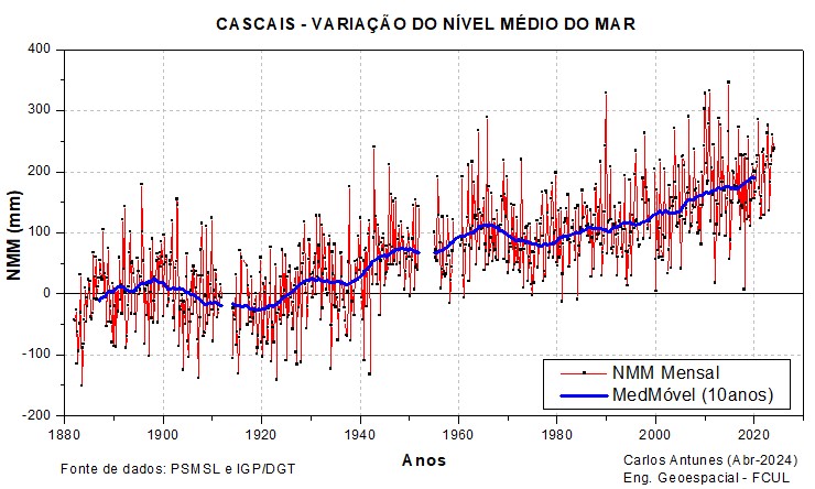
Monthly averages of tide gauge records from Cascais (1882-present), including data from the old analogue tide gauge (jan 1882 – oct 2003), data from the digital acoustic tide gauge (nov 2003 – jun 2019) and data from the digital radar tide gauge (jul 2019 – present). Data from the new digital tide gauges (in Cascais Marina), as of november 2003, are corrected for the vertical movement of the support structure, based on high-precision geometric leveling measurements
Reference in the Portuguese Vertical Datum (Cascais1938, relative to the average of the period 1882-1938).
Annual Variation of the Mean Sea Level in Cascais
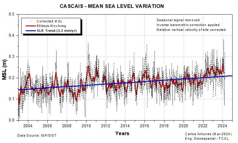
Daily mean sea level series recorded on the Cascais tide gauge (jan 2006 – present), corrected for the mean seasonal variation, the Atmospheric Pressure variation (inverse barometric effect) and the vertical velocity of the site (settling movement of the support structure at Cascais marina).
The most recent uncorrected data (since 2007) can be downloaded from ftp://ftp.dgterritorio.pt/Maregrafos.
With reference of the Portuguese Vertical Datum (Cascais1938).
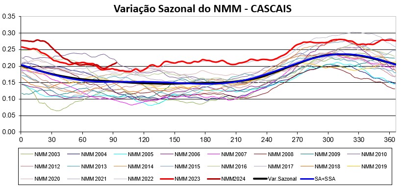
Seasonal Variability of Mean Sea Level in Cascais (2003-2025)
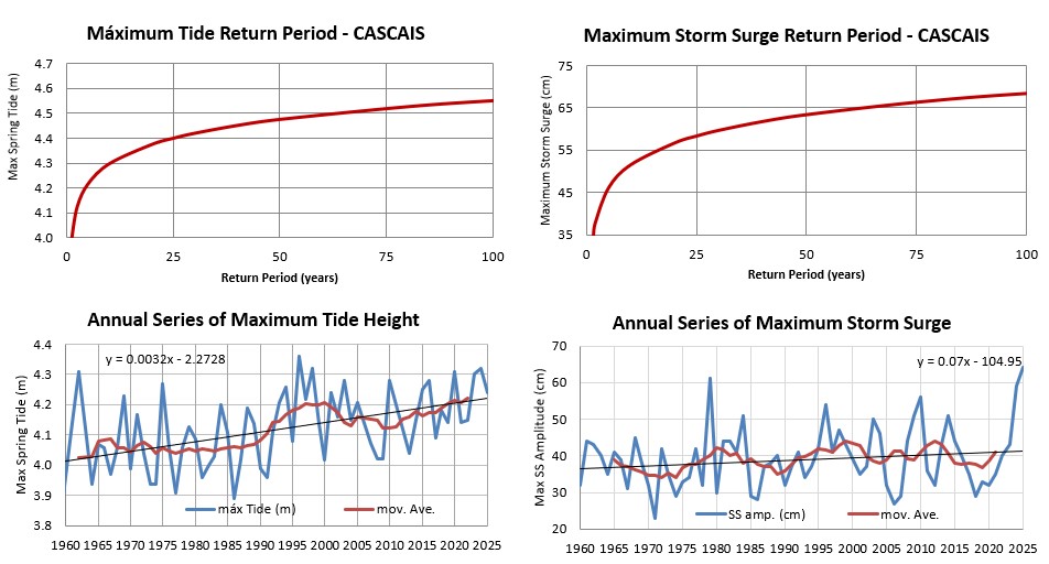
Updated Analysis of Tide and Storm Surge Maximums of Cascais Gauge
Citations:
[3] Carlos Antunes, Gil Lemos (2024). A probabilistic approach to combine sea level rise, tide and storm surge into representative return periods of extreme total water levels: Application to the Portuguese coastal areas. Estuarine, Coastal and Shelf Science, Volume 313, 2025, 109060, doi.org/10.1016/j.ecss.2024.109060
[2] Antunes C., Rocha C. and Catita C. (2019) Coastal Flood Assessment due to Sea Level Rise and Extreme Storm Events: A Case Study of the Atlantic Coast of Portugal’s Mainland. Geosciences, 9(5), 239, doi.org/10.3390/geosciences9050239
[1] Vieira R., Antunes C. e Taborda R. (2012) Caracterização da sobreelevação meteorológica em Cascais nos últimos 50 anos. Actas das 2.as Jornadas de Engenharia Hidrográfica, Instituto Hidrográfico, Lisbon, Portugal.
Mean Sea Level Variation on the West Coast of Iberia (1993-2025)
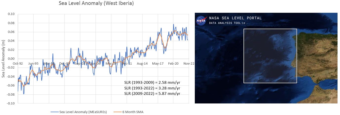
Mean Sea Level variation comparison
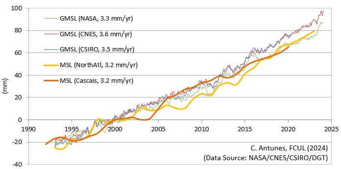
MSL rise series comparison, between the global (GMSL) and North Atlantic (MSL) models from satellite altimetry and the Cascais tide gauge series (1993-2022).
MSL(2000) reference, located 13 cm above the Portuguese Vertical Datum "Cascais1938".
Components of Global Mean Sea Level Variation (1993-2025)

Global MSL components: 1) Altimeter_GMSL is the total volumetric component of Global Mean Sea Level eustatic variation given by Satellite Altimetry of the Topex/Poseidon and Jason 1, 2 and 3 missions (contribution of ocean mass and steric components); 2) OceanMass_SLR is the increase in oceanic mass measured through the GRACE satellite missions (1st mission and Grace Follow-on mission); 3) Steric_SLT is the oceans thermal expansion measured with the ARGO floaters network; and 4) Sum of both OceanMass_SLR and Steric_SLR components.
MSL(2000) reference, located 13 cm above the Portuguese Vertical Datum "Cascais1938".
References:
[3] Watkins et al., 2015, doi: 10.1002/2014JB011547;
[2] Willis, Hamlington, Fournier, 2023.
[1] Beckley et al., 2017.
Global Mean Sea Level Variation (1880-2025)
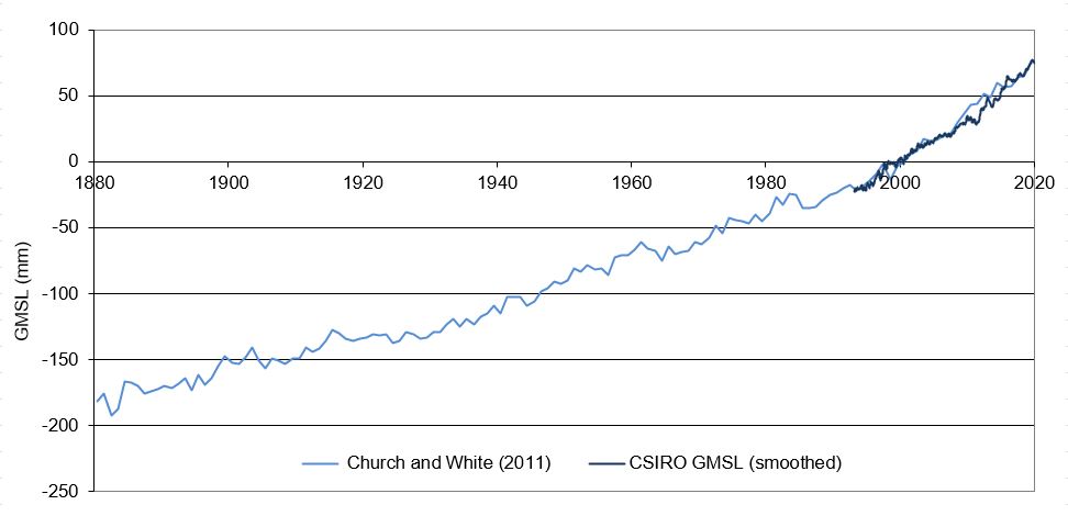
Updated reconstruction of data from the worldwide tide gauge network between 1880-2019 from Church & White (2011) and satellite altimetry data from the Australian CSIRO center (1993-2020) an the French CNES (2020-2025).
MSL(2000) reference, located 13 cm above the Portuguese Vertical Datum "Cascais1938".
Data source:
https://www.cmar.csiro.au/sealevel/sl_hist_few_hundred.html